Cess, Martham, Norfolk
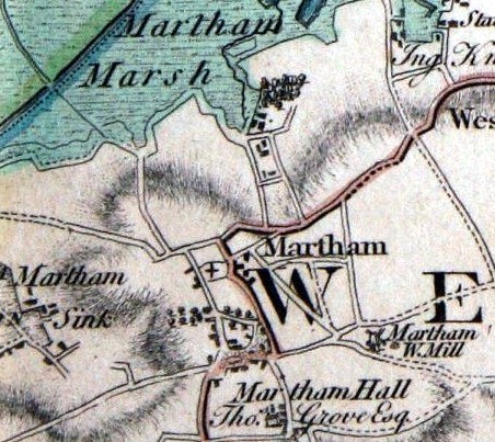
The word Cess means drain or bog, in particular a peat bog. At the time of Domesday in 1086 Cess was written as Ses or Ces. Seace was used in the Stowe Survey of 1292. It is also called Ses in the 1416 and 1424 Court Rolls for the Manor of Martham. Faden’s map of 1797 names it ‘Sink’.
The earliest records for the existence of Cess take us back to Domesday in 1086 and the Stowe survey of 1292. Cess was a popular place to live. It was sheltered, had good soil for growing crops, marsh for cattle grazing and straw for thatch, clay deposits for daub, a dry common providing free grazing at any time of the year and ready access to the river providing fish and eels. Livestock could be driven along Fen Drove which was a green lane running between the wet and dry commons. Access to the common was also available using tracks that later became Cess Road and Common Road. Cess was between the ancient (long lost) hamlet of Sco and within walking distance of St Mary the Virgin by crossing the ‘wongs’. The main route to church was via Church Lane (Sandy Lane). Consequently around 750 years ago Cess had a population to rival that of the centre of the village.
In her book ‘Medieval Flegg’ Barbara Cornford describes how she compared Domesday and the Stowe survey and identified the owners of 16 dwellings that existed along Common Road in 1292. At that time small plots of land containing a house (called a messuage) were called tofts. These were usually surrounded by hedges and were used for livestock at certain times of the year or for crops. The chart below shows the 16 family tofts she identified. The names and plot sizes are actual but their exact position or the order the tofts were in is unknown. The plot holders are listed here in larger font than the map for ease of reading.
- John Herbert 1/2 acre. Toft with messuage.
- William Herbert 1/2 acre. Toft with messuage.
- Richard Anger 1/2 acre. Toft with messuage.
- Robert Spite 1/2 acre. Toft with messuage.
- Herbert Capellanus 2 roods, 23 perches. Toft with messuage.
- William Cupere 11/2 acres. Toft with messuage.
- William Ratheman 3/4 acre. Toft with messuage.
- Adam Ratheman 3/4 acre. Toft with messuage.
- Robert Standard 1acre, 1 rood, 24 perches. Toft with messuage.
- Lawrence Hunbeyn 1/2 acre. Toft with messuage.
- Thos Le Taillour 1 rood with messuage.
- Robert son of William Syk. 1 rood, 32 perches. Toft with messuage.
- William atte Syk 1 rood, 23 perches. Toft with messuage. (At the field named Syk)
- Alan de Syk 1 rood, 23 perches. Toft with messuage.
- Robert de Syk. Messuage.
- Humphrey de Syk. 1 rood with messuage.
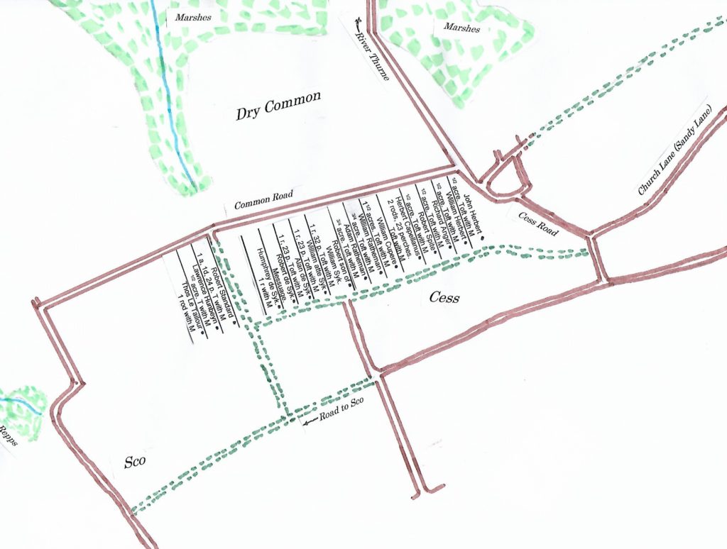
These were not the only tofts in Cess and there were about 80 tofts in all in the village with a messuage and a further 80 without a house probably used for keeping livestock or for crops but were always potential building sites. Three or four of the original 16 cottages still exist and traces of platforms of others can be seen if you look carefully. Notice how some tofts belonging to the same family were grouped together. Larger groupings sometimes gained the family name for the area like Hiltofts or Hardingtofts. In Cess there was Blakemanstofts.
In 1224 Matthew de Gunton, who held most of the manorial land in Martham at the time, gave the advowson (the right to appoint the vicar at St Mary’s) of Martham to Norwich Cathedral Monastery on the understanding that the monks would pray for his soul. From that time onwards because the Cathedral had the advowson they were also entitled to the tithes. These tithes were stored in a great barn at Rectory Farm. This indicates just how important the area was at the time.
A smaller number of early medieval tofts also existed in the Sco area facing west. Access to and between the large number of homesteads gave rise to many footpaths some of which still exist today. For more details about footpaths throughout Cess click HERE.
Cess had four Smees which were ancient small areas where local people had a right to remove clay for road making or daubing on their houses. You can read more about Smees by clicking HERE.
Before the opening of the Workhouse in Rollesby in 1776 the destitute were housed by the Parish authorities in a house which was at the end of what is now Cess Lane at or adjacent to Willowcroft.
As a result of the 1812 Inclosure Award a staithe was built on the River Thurne at the north end of Cess Road “for the use and convenience of the owners and occupiers of estates within the Parish of Martham…. For the depositing thereon of the corn, manure and other things which shall be conveyed …. by the said river. This was good for larger landowners but conversely the same Act closed the Common and small farms, bringing hardship to many small toft owners.
By the time of the 1842 Tithe Award the following people had become the owners of the land at or near the 16 tofts identified above. They were: William Ransome*, William Pollard*, John Greenacre*, Mary Proctor*, Ann Francis and the Dean & Chapter of Norwich Cathedral. (* These owners also lived there).
The railway, opened in 1877 and cut diagonally across the area bringing alternative work and three level crossing Gatehouses which you can read more about by clicking HERE. The Victorian era also brought diversification in farming notably blackcurrant production to both Cess and the rest of the village. You can read more about blackcurrant farming in Martham by clicking HERE. Both these changes resulted in a growth in Victorian terraced housing in Cess epitomized by Bracey’s Terrace and Jubilee Cottages.
Given the age of the area it is perhaps not surprising that there remains a number of fascinating older houses some of which are listed on the map below and feature elsewhere on this website.
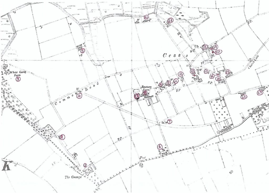
Key:
1. The Grange formerly West End Cottage.
2. Beverley Cottage, Common Road.
3. White Gates Farm off Common Road.
4. Gatehouse No40, Common Road.
5. Common Farm off Common Road.
6. Rectory House, Repps Road.
7. Gatehouse No41, Low Road.
8. Rectory Farm (centered on East & West Cottages).
9 ?
10 ?
11 ?
12. East Farm Cottage.
13. Cess Farm, Cess Road.
14. Rose Farm, Cess Road.
15. Conyard Farm, Cess Road (bottom of Sandy Lane).
16. Conyard Villa, Cess Road (next to Martham Boat Building Co.)
17. Ribena Bungalow, Cess Road.
18. Willowcroft, Cess Lane.(Possible site of former Town House).
19. 1 & 2 Coronation Cottages, Cess Lane.
20. 1 & 2 Goose Cottages, Cess Lane.
21. Smee Farm, Cess Road?
22. Former site of Alberta House.
23. Former site of Pear Tree Farm.
24. Francis Farm (was once a pair but now one house?)
25. Roselea? (Former site of Country Motors car scrapyard).