Anglo-Danish Martham
This is an account of the Anglo-Danish Village of Martham; its pre-Domesday Tenants and their conversion into the Customary Tenants of a feudal manor in 1101. Based on a report by Rev. William Hudson.
Martham is unusually fortunate to have preserved documents illustrating its development from the earliest times. They begin with two short but very valuable notices in the Domesday Book (1086). The Dean and Chapter of Norwich, who were the successors to the Prior and Convent (the former lords of the manor), provides many Manorial Rolls from 1272 to the middle of the 14th century.
Their place was taken by a series of Court and Bailiffs’ Rolls covering the period to the Reformation in the 16th century at which time the Manor fell into private hands. In addition to these there is another very exceptionally important survey of the Manor that was carried out in 1292 which is held by the British Museum and is called the Stowe Survey. This survey provides the names of 107 “former” holders of units of land differing considerably in size. These holdings were (as was usual in those days) made up of strips of land, often widely separated from each other. In 1292, by partition on death of a holder, or for other reasons, these 107 units were held in more than 900 names and the number of furlong strips held had become more than 2,000. Every strip is given the name of the “field” it is in; the name of the tenant whose lands it adjoins on its long side and the land or road it abuts on its short side. The tenants are exclusively described as holding the land in “villenage” or in “socage”. There were 221/4 villenage* tenements consisting of 12 acres (or fractions) each. They were called “eruings” which was derived from the old Saxon word “eruing” meaning ploughing.
*Villenage was the tenure by which land is held from a lord. Socage was a feudal tenure of land involving payment of rent or other non-military service to a lord.
Earlier on, the Domesday Book of 1086 had plots as being occupied by “freemen” under no obligation to a lord. Later, in 1101, the first Bishop of Norwich, Bishop Herbert de Losinga gave the land to his newly founded Monastery for the maintenance of his monks and converted his rights of patronage into those of a lord of the manor to be tilled by the tenants for the benefit of the monks. So, it appeared that the date when the “former” tenants held their land might not unreasonably be carried all the way back to the creation of the manor and were thus linked to the freeholders in the Domesday Survey.
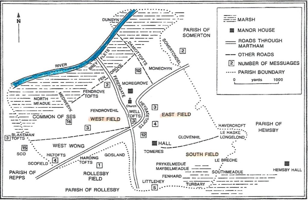
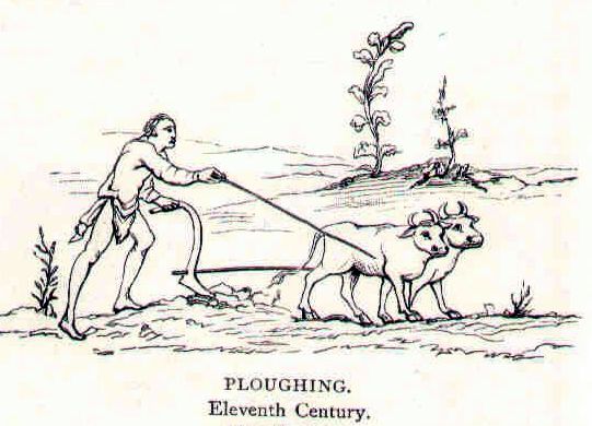
It is clear that the naming of Martham is of Angle origin by the termination of its name and the occurrences of the Angle “eruings” in official records of the village. Under this system there were three great fields; Westfeld, Estfeld & Suthfeld. The three-field system of cultivation meant that two of the fields were sown each year in rotation and the third was left fallow. At first the land was parcelled out in strips and assigned in various proportions with each holder having an equal number of strips in each field. From time to time a redistribution of strips took place. The ploughing and other cultivation operations were done in each field according to a common plan. Although the lands were said to be held in common the tenants were not a community in the modern sense. Each man was a master of his own strips. After several generations of agriculture, the better class of tenants preferred a more permanent kind of tenure and their holdings became theirs in perpetuity and when they died the land passed to their heirs and successors. They could even part with their holdings by sale or exchange. The permanency of the tenures did not necessarily change the system of common cultivation which involved the shared use of ploughs by co-operation. The use of the word “eruing” given in the survey had some connection with a plough and most likely implied that the holder was expected to provide a quarter of a plough team, or two oxen towards a team of eight. So, the picture was three great fields parcelled out into sections of 12 acre eruings, four of which were supplied with a plough. This map is a modern illustration of the three-field layout.
Later evidence shows that such a system of sets of 12 acre and ten-acre tenements continued in existence, not for plough teams but for the election of reeves (an official appointed by the lord to collect rents in return for the use of land) and harvest workers right down into the 14th century.
The Danish Settlement of Martham
Agricultural development meant that Martham no longer stood alone on the Flegg Island with its neighbours Somerton and Winterton. Adjacent were the Danish ‘by’s of Hembsy, Rollesby and Ormesby. Of these Hemsby was the one that was destined to be chiefly connected with Martham. Whilst the Midlands and most other English villages had passed into a condition of feudal manors, that is tenants under the control of a lord. East Anglia still had a considerable number of places where owners of land were still ‘freemen’. They were not altogether free and were subject to some commitment to a lord but they did not work his land. There was a group of 36 of this type of freemen in Martham who owned over 600 acres of land plus pasture between them. In addition, there were a number of other “socmen” working with them that were only discovered through the Stowe survey. At the time of Domesday in 1086 Hemsby was a feudal manor and after several more or less violent changes of ownership fell into the hands of Aylmer, the Bishop of Elmham who likewise possessed about a quarter of the land in Suthfeld which is called a “berewite” meaning an outlaying portion of his main land holdings in Hemsby. This, Martham, holding consisted of 240 acres. It seems that later this became the demesne of Bishop Herbert de Losinga’s Manor of Martham which was mentioned earlier.
Demesne – is land attached to a manor and retained by the owner for their own use. The manor consisted of demesne land (private land of the lord) plus tenants’ holdings.
Formation of the Manor of Martham
A close comparison of Domesday and Stowe has identified the same base holding by 36 freemen over the period from 1086 right through to 1292 although subsequently sub-divided by inheritance and sales, holdings had been divided by eight to twelve times the original number. Similarly, the holdings of the 27 socmen from Hemsby can be traced and they also held 30 acres of land in Martham. There seems little reason to list them separately other that they came from Hemsby and held Martham land without living here but subject to providing 27 half days harrowing for the Martham lord. According to the Rev. William Hudson it seems reasonable to believe they were Danish settlers living on land outside the three-field system.
The Stowe Survey makes it clear that in 1101, within 15 years after the Domesday Book was compiled, Bishop Herbert de Losinga gave his Manors of Hemsby and Martham to his new Priory of Norwich. The greater part of Martham had not previously been subject to manorial conditions. The Bishop made the 36 freemen into “villenage” tenants and in addition 27 socmen from Hemsby into customary tenants with specified obligations of service to the Norwich Priory monks. This included 15 acres in Sco which was a hamlet between Martham and Repps probably where Grange Farm is today.
It is something of a surprise to find that the whole body of the old common lands of Martham were suddenly converted into tenancies. Whilst it is true that their freedom was limited even in Martham the lord’s rights were similar to the rest of England but perhaps less onerous. As villeins they were previously in some way under the control of a lord. The lord, for his own purpose could choose to interpret that relationship as giving him authority to require services and the villeins had no power of resistance thus their obligations were transferred by Bishop Herbert de Losinga to his new Prior of Norwich.
The Church
At the time of Domesday churches in England were mainly provided by the lords of manors and placed near the hall without regard to the existing layout of the manorial lands. In Martham, however, the church is not mentioned in connection with a lord or a manor but with the 36 freemen. Its holding of 50 acres of land implies a community asset in a prosperous condition. This endowment probably dated from 11th century when holders of the eruings had been reinforced by the Danish socmen and the combined community held at least 500 acres of land.
In Angle times the main road would have lead from somewhere near the Burgh (Burgh St Margaret) through Martham to Somerton and Winterton. It passed the church and the three-field system took its field names from their relationship to this central point.
Field Boundaries
So far as we can tell Ferrygate was the dividing line between Westfeld and Estfeld. The boundaries of the Suthfeld are less easy to determine. They may have been disturbed by the settlement of Hemsby, Ormesby and Rollesby and the socmen occupiers from Hemsby. By the time of the 1292 Stowe Survey the shrunken Suthfeld seems to have lain entirely between the Rollesby and Hemsby Roads. The 24 eruings should have consisted of 8 in each field with each providing two plough-teams. This seems to have applied to the Estfeld and Westfeld although several minor fields had been added to the system by 1292. Each had about 86 to 90 acres but this included areas for “tofts” (homes). What is certain during the late 10th century and 11th century is that the land usage slowly changed as a result of the influx of Danish settlers. By 1292 the Suthfeld amounted to about 39 acres. But there was a field named ‘Tomeres” of 43 acres and another called “Clovenhouse”, laying north of the Hembsy Road which belonged to the Prior and another named “Gosland” which may have been part of the Estfeld area.
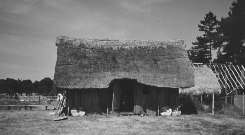
The Tofts
As far as we can tell about one quarter of a 12-acre holding was set aside for a house and for keeping of the necessary oxen and poultry. The word “toft” is Danish so again may be associated with the settlers. It seems that the tofts were not grouped together in the village but were scattered about the district. The village green was probably there but there was no inn, no baker and no butcher to attract the residents. The tofts were situated where they ploughed and the oxen were in use.
Still there were some grouping of homes and some are listed in the Stowe Survey at Fendrovetofts which was just west of Ferrygate Lane. Whilst another group were located north of the church in the angle between Ferrygate on the west and Somerton Road. Another early group was called Welletofts and may have been in the Westfeld near the village green. Most of the tofts were called by the name of the former 1086 holder. One that illustrates this well was called after the tenant named Yware Blakeman. It was of six acres to the east of the Common. In 1292 it was held by ten persons with all of the separate strips being described as in Blakemanstofts. The whole forms a complete block or furlong which is a good illustration of many other similar holdings.
There are many other examples e.g. a holding by Roger De Hil called Mutelond and formerly of 10 acres had become 11 tenants. And, a former holding of 12 acres by Thos Knight became 12 tenants. A former holding of 22.5 acres by Thos De Syk had 12 tenants. The holdings by the separate tenants were not separately cultivated. The whole was sown with the same crop and reaped in common. The subsequent adjustment of the share out of the produce could not always have been easy.
Stowe 1292
Among the Surveys of the Manors of the Prior of Norwich contained in the volume known as Stowe Survey (MS. 936 in the British Museum) is one which has features of unique interest. It is the Survey of the Manor of Martham. The whole compilation, unfortunately, is in a defective condition. The series was apparently started soon after the appointment of William de Kyrkeby to the Priory in 1272, and was continued at various dates, the survey of Martham being made by the Prior of Norwich, Henry de Lakenham in 1292.