Martham as part of the Isle of Flegg
This page provides a description of how Martham fits in with its neighbouring villages on the Isle of Flegg. The name Flegg comes from an old Danish word flaeg used for all sorts of marsh plants. “The place where reeds grow” is a very suitable description of the Isle of Flegg with its extensive marshes and water-logged peat soil.
The Isle of Flegg is so named because in times past whichever way you approached it you had to cross water to get there – a true island. This is not quite true anymore but almost still applies. The map below illustrates this.
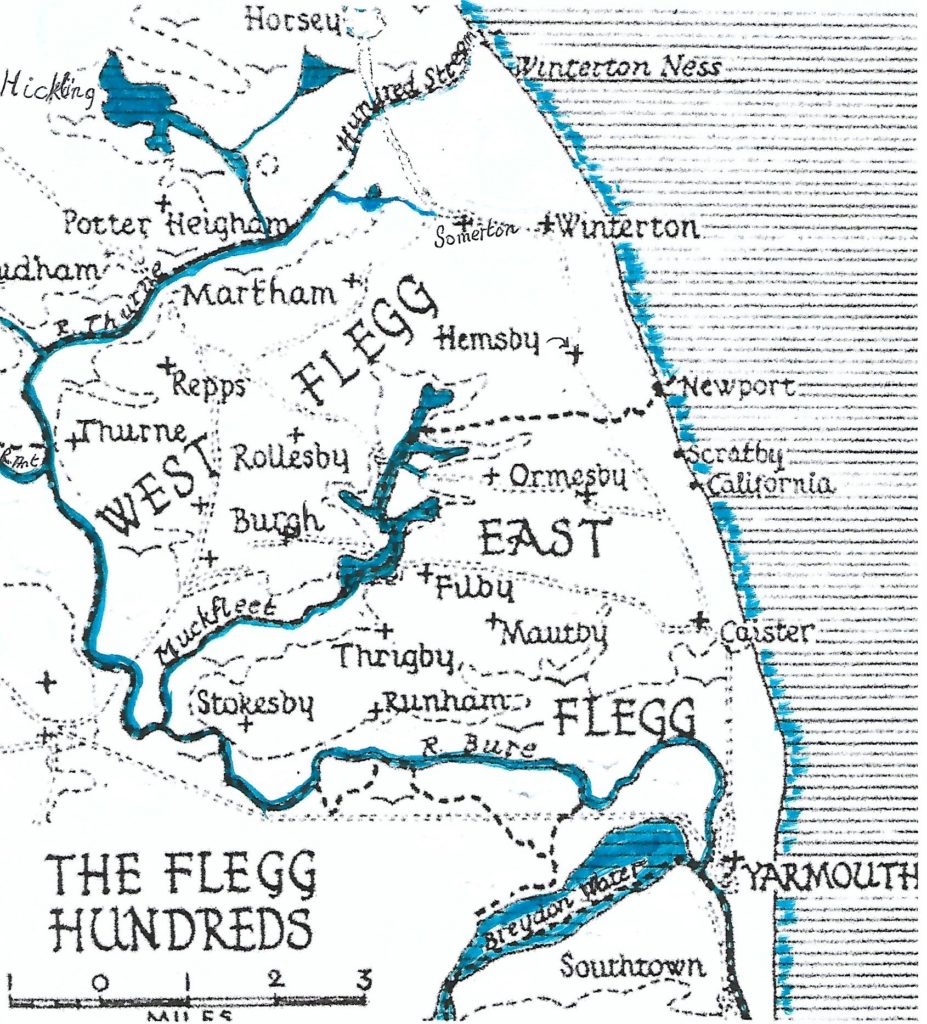
The southern boundary of the island, heading north out of Great Yarmouth, is the River Bure. The Bure then forms much of the western border passing the Muck Fleet on your right (east) and then onwards until its junction with the Rivers Ant and Thurne. The Thurne continues north for a short distance and then turns east. It passes to the north of Martham and then, originally, became the Hundred Stream all the way to the coast where it flowed into the North Sea between Winterton and Horsey. The Hundred Stream is now a dried-up river which the Somerton to Horsey road crosses over an almost indistinguishable culvert bridge at what are still marshes. Just about the only way you can leave Flegg Island without crossing water now is to walk northwards along the beach or dunes from Winterton into the parish of Horsey. The Hundred Stream is the ancient boundary between West Flegg and Happing hundreds.
The Island consists of two of the smallest hundreds in England being East and West Flegg. East Flegg extends about five miles along the coast northward from Yarmouth and about seven miles westward, on the north side of the river Bure which divides it from Walsham Hundred. The east contains the parishes of Caister-on-Sea, Filby, Mautby, Ormesby St. Margaret with Scratby, Ormesby St. Michael, Runham, Stokesby-with-Herringby, Thrigby, and West Caister.
West Flegg is bounded by East Flegg to the south, Walsham Hundred to the west, Happing Hundred to the north and the North Sea on the east. It extends about 3½ miles along the coast and 7½ miles inland. It rises to the highest part of the island which is about 48ft. above sea level. The west contains the parishes of Ashby with Oby, Clippesby, Fleggburgh with Billockby, Hemsby, Martham, Repps with Bastwick, Rollesby, Somerton, Thurne, and Winterton-on-Sea.
Martham sits on the northern edge of the island with its Broad which is fed, and drained, by the River Thurne.
At the very centre of the island are the Trinity Broads. The most northerly of these is Rollesby Broad, the central one Ormesby Broad and the most southerly, Filby Broad. The broads drain into the River Bure via the Muck Fleet.
When the Romans arrived at Caister-on-sea 2000 years ago the island was much more distinct, being clearly surrounded by water. Great Yarmouth did not exist and in its place was a wide estuary. The Isle of Flegg looked like this 2000 years ago:
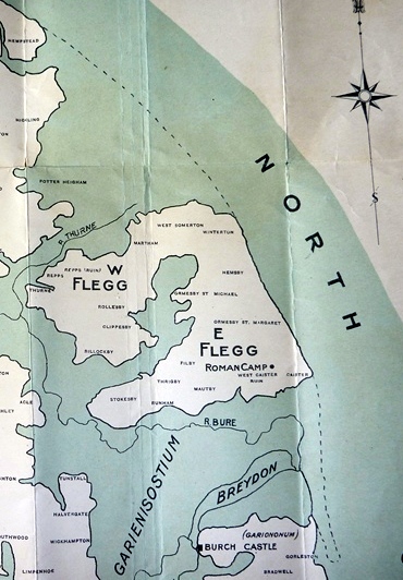
To the north of Martham, Somerton and Winterton was a large shallow estuary or swampland. It is likely that flat bottomed boats could enter this area from the sea and land at or near the coast off Martham if desired.
During the Romano-British period (AD43-410) the first proper towns and roads appeared along with villa estates and many farmsteads. There were two Forts, one located to the south of the isle at Caister-on-Sea and the other across the estuary at Burgh Castle. The evidence for Romano-British settlement in Martham is based on a small number of artefacts found in the village.
More about the Isle of Flegg can be found during the following periods by clicking on these headings:
Inspired by this page Hugh Turner undertook his own exploration of the Isle of Flegg and wrote about his adventures. I am grateful to him for sharing his informative story that you can read by clicking HERE.